Community Engagement
Fire is reshaping one of Africa's most important wildlife landscapes
Fire is reshaping one of Africa's most important wildlife landscapes
August 18, 2026
By Tawanda Muhamba, GIS Analyst, IFAW
For years, satellite imagery has offered a window into one of the world's most important conservation landscapes.
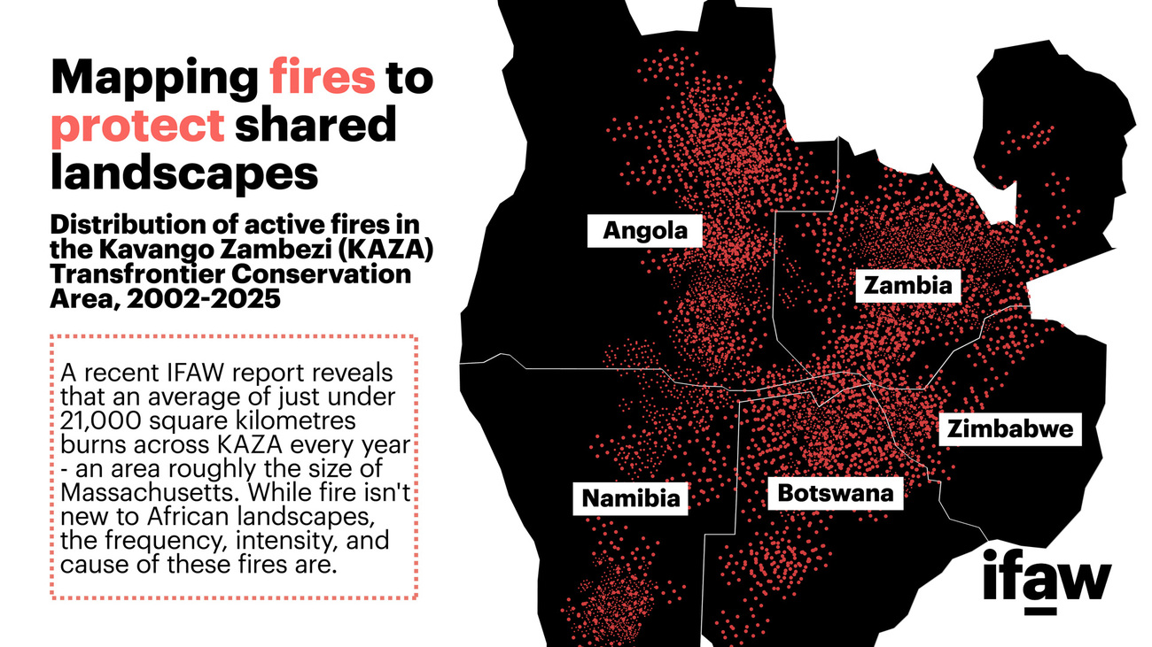
Stretching across Angola, Botswana, Namibia, Zambia, and Zimbabwe, the Kavango-Zambezi Transfrontier Conservation Area (KAZA) is home to around 228,000 savannah elephants, more than half of Africa's remaining population, alongside more than 2.5 million people who share this landscape with wildlife.
It is also one of the most connected conservation landscapes on Earth, linking protected areas, community conservancies, forests, and wetlands across five countries.
The landscape is central to IFAW's Room to Roam vision, which works to secure, connect, and protect critical wildlife corridors so elephants and other species can move freely across southern Africa.
When 23 years of fire data from across KAZA were brought together, the picture that emerged was striking.
Using data collected by NASA's Moderate Resolution Imaging Spectroradiometer (MODIS), a satellite system that scans the Earth's surface every one to two days, fire activity across the region was tracked between 2001 and 2023. The results revealed a landscape under growing pressure. On average, more than 21,000 square kilometers (8,100 square miles) burn across KAZA every year, an area larger than Rwanda.
Fire has always been part of African ecosystems. Many habitats evolved alongside it, and when it occurs at the right time and intensity, it can play an important ecological role. What is concerning is how often fires are occurring, how much land they are affecting, and the increasing role of human activity in driving them.
A landscape under growing pressure
Over the past two decades, fire frequency across KAZA increased by 34%, while forest cover declined by 18%. Today, only 42% of the landscape remains intact woodland. In many places, repeated burning is reducing the ability of forests and woodlands to recover, leaving behind more degraded and less resilient habitats.
What makes this analysis particularly powerful is that it is based on direct observations rather than projections. The satellite record allows changes across the landscape to be tracked year after year, revealing patterns that might otherwise go unnoticed.
The reality may be even more concerning. Dr Pieter Oliver of M.A.P. Scientific Services, who reviewed the findings independently, notes that satellite records are likely capturing only part of the picture.
"The IFAW analysis likely underestimates the true scale of fires," he explains. "Satellite data cannot detect many small fires, which are common in African landscapes due to activities like farming and land clearing. Higher-resolution imagery captures about 75% more fire events than broader datasets capture."
In other words, while the long-term trends identified in the analysis are clear, the actual extent of fire activity across the landscape may be even greater than current records suggest.
What's driving the fires
One of the clearest findings from the study is that people are at the center of this story.
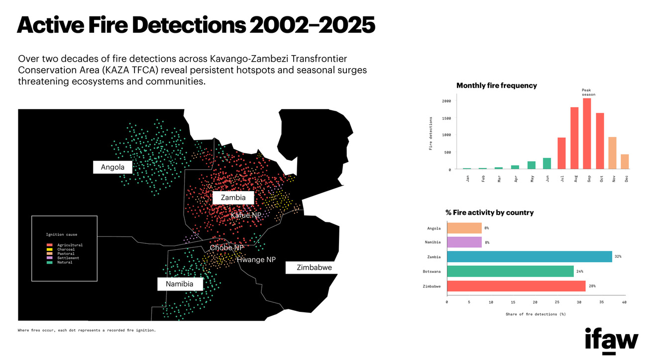
Nearly 70% of fires across KAZA can be linked to human activities such as agricultural clearing, grazing management, and charcoal production. Agricultural burning alone accounts for around one-third of all fires, while charcoal production contributes a further 18%.
These activities support livelihoods across the region. For many rural communities, fire remains one of the most accessible and affordable tools for managing land and natural resources. The challenge comes when fires spread beyond their intended boundaries or occur too frequently for ecosystems to recover.
This distinction matters. The issue is not simply about reducing fire, but about helping communities manage it more safely and sustainably. As demand for land and energy grows, solutions will need to work alongside people, recognizing both their needs and their role as stewards of the landscapes they call home.
When wildlife loses room to move
The consequences of repeated burning extend far beyond the burn scars visible from space.
During the peak fire season between July and October, wildlife is already facing the toughest conditions of the year. Water becomes scarce, food resources decline, and animals concentrate around remaining water sources. The analysis found that habitat displacement during this period can reach 90–95% for species such as elephants and African wild dogs.
When animals are pushed from their preferred habitats, they are more likely to move into areas where people live and farm. This increases the risk of human-wildlife conflict, disrupts migration routes, and places additional pressure on already vulnerable wildlife populations.
One of the most concerning findings relates to the Hwange-Kazuma corridor, a critical wildlife pathway connecting elephant populations in Zimbabwe and Botswana. The data shows that approximately 75% of the corridor is affected by recurring fire disruption.
Having worked in and around the Hwange landscape and seen how heavily elephants rely on these connections to move across borders, the scale of that disruption is sobering.
For elephants and many other species, connectivity is essential. Wildlife corridors allow animals to move between habitats, access food and water, maintain genetic diversity, and adapt to changing environmental conditions. When those connections begin to break down, the impacts ripple across entire ecosystems.
The findings reinforce why connectivity is such an important focus of IFAW's Room to Roam initiative. Across southern Africa, Room to Roam works with governments, communities, and conservation partners to secure, connect, and protect critical wildlife corridors, helping elephants and other wildlife move safely through landscapes shared with people. By reducing habitat fragmentation and strengthening landscape connectivity, the initiative supports biodiversity, climate resilience, and human-wildlife coexistence across the region.
Fire is not only affecting habitats within protected areas, but also increasingly disrupting the corridors that connect them. Protecting these pathways will be critical to ensuring wildlife can continue to move, adapt, and thrive across the KAZA landscape.
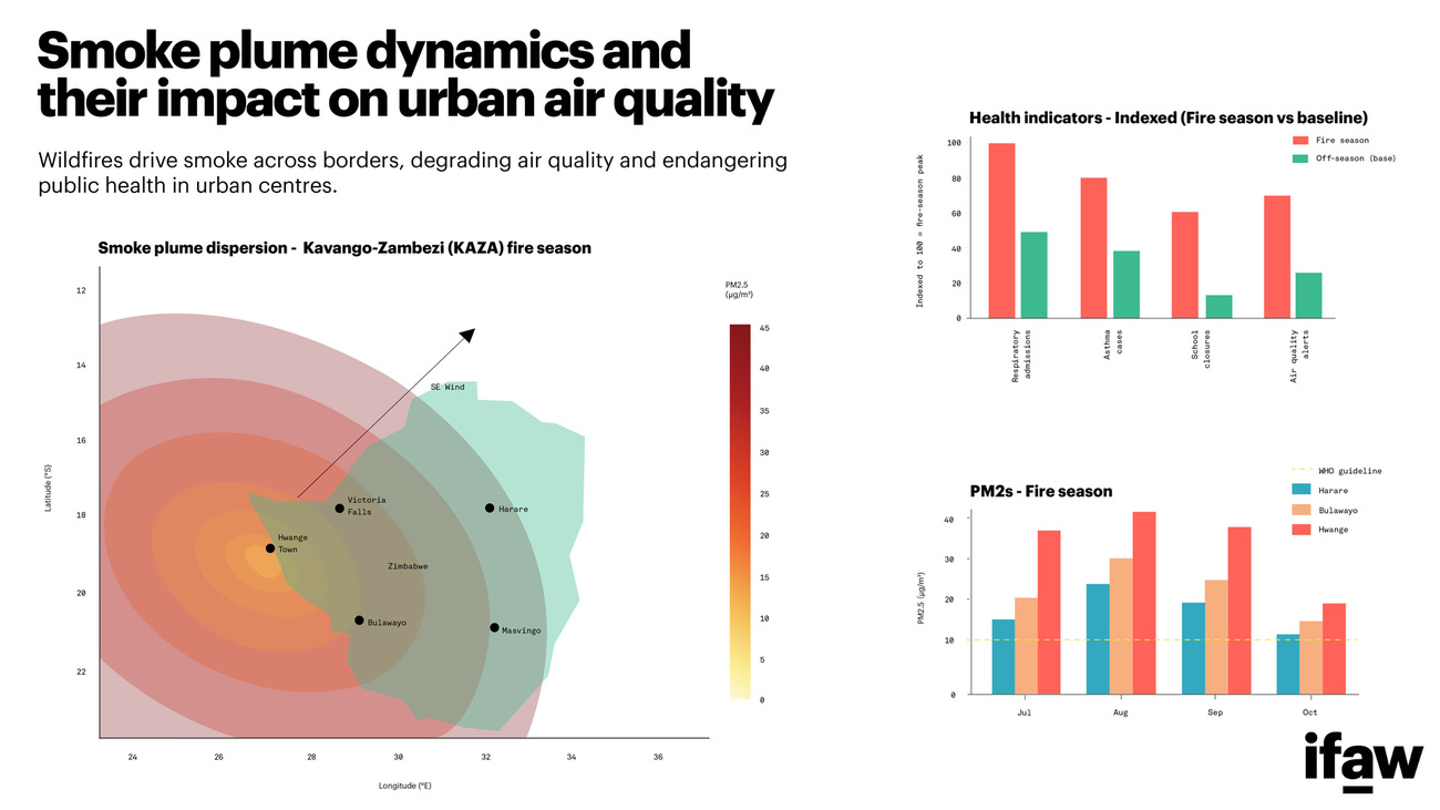
The impacts are not limited to wildlife. Smoke from uncontrolled fires can travel hundreds of kilometers, affecting air quality far beyond the burn sites. For communities living in fire-prone areas, these impacts can become an annual challenge, affecting health, livelihoods, and overall wellbeing.
Turning evidence into action
Despite these challenges, there is reason for optimism.
One of the most encouraging findings from the research is that the majority of fires are preventable. Because they are linked to human activity, there are practical interventions that can make a measurable difference.
Across parts of the region, communities are already testing approaches such as early-season controlled burning, local fire management committees, and improved fire detection systems that allow faster responses before small fires become major events.
The study highlights several actions that can help reduce fire impacts across KAZA:
- Supporting community-led fire management and controlled early-season burning.
- Expanding early warning systems and real-time fire detection.
- Protecting critical wildlife corridors through targeted fire management.
- Supporting sustainable livelihoods that reduce dependence on charcoal production.
- Strengthening cooperation between the five countries that share responsibility for the KAZA landscape.
None of these solutions can succeed in isolation. Fire does not recognize political boundaries, and neither should our response.
A future still within reach
After analyzing more than two decades of fire activity across KAZA, one conclusion stands out above all others: this is not an inevitable problem.
The data tells a serious story, but it also points towards practical solutions. The same evidence that reveals the scale of the challenge shows where action can make the greatest difference.
KAZA remains one of the world's most remarkable conservation landscapes. It supports extraordinary wildlife, sustains millions of people, and demonstrates what is possible when countries work together across borders.
By supporting communities, protecting wildlife corridors, improving fire management, and strengthening regional cooperation, it is possible to reduce the impacts of fire and build a more resilient future for people and wildlife alike.
That future remains within reach. The evidence shows where action is needed, and the opportunity to act is now.
Related content
every problem has a solution, every solution needs support.
The problems we face are urgent, complicated, and resistant to change. Real solutions demand creativity, hard work, and involvement from people like you.