Blog
Local champions helping elephants and people share the landscape
Read moreHow an app is helping keep people and elephants safe in Malawi and Zambia
By Zanji Valerie Sinkala
In Zambia’s Eastern Province, where the Lukusuzi and Kasungu National Parks meet through a corridor of human settlement, human-elephant conflict has become a serious threat.
More than 15,000 people live within key elephant migration routes in the Malawi–Zambia Elephant Landscape. As habitats become increasingly fragmented due to encroachment and deforestation, encounters between elephants and people have increased. Crop raiding, particularly of maize, is now a dominant form of human-wildlife conflict.
This region is connected to the Luangwa Valley ecosystem, home to Zambia’s largest elephant population of approximately 15,000 individuals. Yet, despite having a suitable habitat, Lukusuzi had none recorded in 2020. This is largely due to lack of water in the park, settlements in wildlife corridors, poaching, and an increasing human-wildlife interface driven by rapid human population growth (estimated at 2.9% per annum) and poor land-use planning.
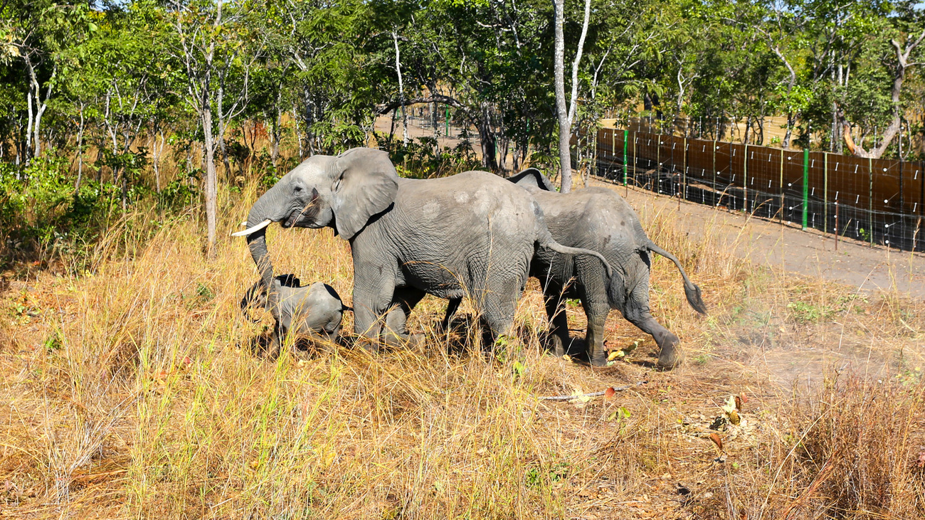
This enormous reduction in elephant population did not happen to Lukusuzi alone, but also in neigbouring Kasungu National Park in Malawi. The population of elephants in Kasungu had reduced from approximately more than 1,000 to only about 50 by 2015. In an effort to restock Kasungu, Malawi Department of National Parks and Wildlife (DNPW) translocated 263 elephants and 400 other animals of various species to Kasungu in 2022.
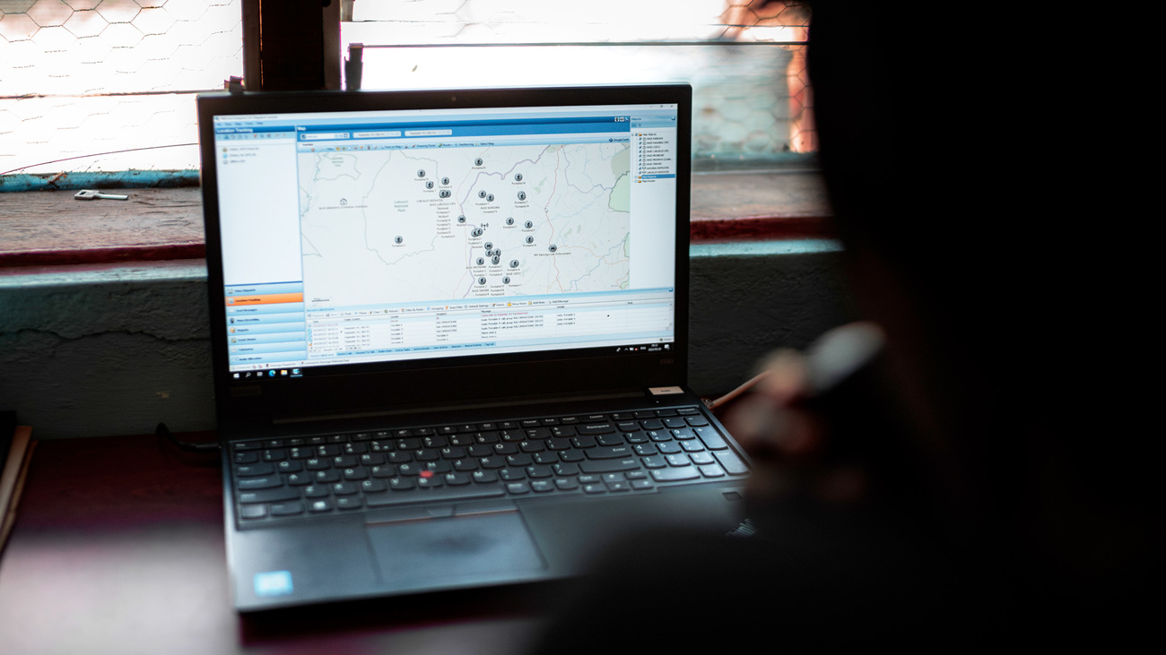
To help communities and wildlife coexist, IFAW equipped DNPW rangers and wildlife authorities with the EarthRanger tool, a real-time elephant tracking app that has transformed human-wildlife conflict management in this landscape.
With support from IFAW and partners, 28 elephants in Kasungu—mostly matriarchs—were fitted with GPS collars as part of the translocation. As each matriarch leads a group of at least 10 elephants, ranging from newborn calves to adults, EarthRanger makes tracking herd movements across borders possible. Around Kasungu, a virtual fence set one kilometre from the park’s boundary monitors collard elephants’ movements.
When a collared elephant approaches the virtual fence, the app sends SMS alerts to rangers and DNPW officers, mobilising rapid response units (RRUs) and primary response teams (PRTs) trained and stationed in conflict-prone villages.
‘EarthRanger helps us make informed decisions in our responses to elephants,’ says O’Brian Hamoonga, Wildlife Park Ranger with the Zambia DNPW. ‘It gives us early warning detection and raises the alarm for officers placed in hotspots. We can react before a conflict is experienced.’
These alerts help avert conflict. Equipped with EarthRanger-enabled smartphones and GPS-guided apps, field teams receive coordinates of incoming elephants and can quickly respond using non-lethal deterrents, such as firecrackers and chili blasters. EarthRanger has drastically improved the speed and coordination of responses.
‘Each time elephants cross the Kasungu National Park boundary, we receive alerts through EarthRanger directly to phones,’ explained Chris Kaoma, IFAW Zambia Field Operations Manager.
Human-elephant conflict management no longer stops at incident response. EarthRanger enables long-term conflict prevention. The platform collects real-time data on conflict types, spatial patterns, and mitigation effectiveness, all of which feed into a dedicated dashboard at Lukusuzi National Park. These insights refine land-use plans, identify seasonal elephant corridors, and inform national strategies.
From 2001 to 2023, Kasungu lost 890 hectares of tree cover, equivalent to a 1.9% decrease in tree cover since 2000, driven by slash-and-burn farming, fuelwood harvesting, and charcoal production. With EarthRangers’ integration into land-use planning tools, conservation teams can now model elephant habitat suitability, track changes in land cover, and prioritise zones for conflict mitigation. This science-backed approach enhances coexistence planning across the 23,750-square kilometre Malawi–Zambia Elephant Landscape.
‘EarthRanger also gives us information about where human-elephant conflict is most prevalent,’ O’Brian added. ‘We can now generate real-time reports that help us act fast and inform others.’
By combining advanced technology with community-led conservation, IFAW’s Room to Roam initiative gives elephants the space they need and helps animals and people thrive together. EarthRanger is a lifeline in a landscape where the futures of people and elephants are deeply intertwined.
Every problem has a solution, every solution needs support.
The problems we face are urgent, complicated, and resistant to change. Real solutions demand creativity, hard work and involvement from people like you.
Unfortunately, the browser you use is outdated and does not allow you to display the site correctly. Please install any of the modern browsers, for example:
Google Chrome Firefox Safari